ST_EstimatedExtent
Signatures
GEOMETRY ST_EstimatedExtent(VARCHAR tableName);
GEOMETRY ST_EstimatedExtent(VARCHAR tableName, VARCHAR geometryColumn);
Description
Return the ‘estimated’ extent of the given spatial table (tableName).
The Extent is first calculated from the spatial index of the table (if there is one).
If the pointed geometry column (geometryColumn) doesn’t have a spatial index, then the extent is based on all geometries.
This function is fast, but estimation may include uncommitted data (including data from other transactions), and may return approximate bounds, or be different with actual value due to other reasons.
Warning
Only 2D coordinate (XY) is supported
Examples
Case with tableName
DROP TABLE IF EXISTS myTable;
CREATE TABLE myTable (THE_GEOM GEOMETRY(LINESTRING));
INSERT INTO myTable VALUES('LINESTRING(1 1, 5 5, 7 2)'::GEOMETRY),
('LINESTRING(1 4, 3 1, 4 7)'::GEOMETRY),
('LINESTRING(5 2, 7 6)'::GEOMETRY);
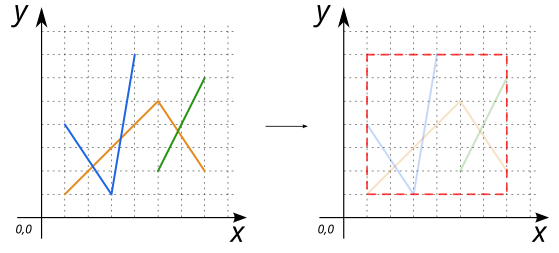
SELECT ST_EstimatedExtent('myTable');
-- Answer: POLYGON ((1 1, 1 7, 7 7, 7 1, 1 1)) (red dashed line)
Case with tableName and geometryColumn
DROP TABLE IF EXISTS myTable;
CREATE TABLE myTable (THE_GEOM GEOMETRY(MULTIPOLYGON, 4326));

INSERT INTO myTable VALUES(ST_MPolyFromText('
      MULTIPOLYGON(((28 26,28 0,84 0, 84 42,28 26), (52 18,66 23,73 9,48 6,52 18)),
                   ((59 18,67 18,67 13,59 13,59 18)))', 4326));

SELECT ST_EstimatedExtent('myTable', 'THE_GEOM');

-- Answer: SRID=4326;POLYGON ((28 0, 28 42, 84 42, 84 0, 28 0)) (red dashed line)